
Creating a park plan for downtown Toronto: A flexible public space system
This is the second in a trilogy about TOCore, the City of Toronto’s initiative to create a parks and open space master plan for the downtown (among other related planning things). In the last post I broke down the challenges and some potential solutions to buying parkland downtown. Next week’s post will be about programming and community engagement.
What do you do when you have a tiny apartment that needs to be a living room, a kitchen, and a bedroom all at once? You get a bunch of furniture that folds up, packs away, and flips down. Your bed lifts up and reveals a desk underneath. A kitchen table flips down from a wall. A book opens up a secret passage way to reveal a long tunn—wait, that’s different.
The point is we create flexible spaces all the time in our homes, but we often don’t extend that same thinking to our cities. Here’s a street: this is where cars drive and park. Here’s a park: this is where we play. Etc.
But with such limited space downtown, flexibility is key
The conversation around parks in downtown Toronto is often that the City needs to buy land for new parks. And it does, no question about it. But what’s talked about less is how we can better use the land we already have. In this post, I want to dive deeper into some of the design issues around parks in dense growing areas, particularly how we can be more creative by blending our public spaces together and building in adaptability.
We need the city equivalent of a bed that folds up to reveal a desk
What if a roadway was designed so it could become a plaza during the warmer months? Now what if that road was actually along the edge of an existing park so that the park could get “bigger” when it needed to?
This thinking is slowly coming to Toronto. In fact, the City’s Downtown Parks Background Study notes that “in terms of urban park design, it can be advantageous to extend the look and feel of a park beyond its designated boundaries.” City Study, I could kiss you on the mouth. Because…
Our biggest public space resource is not our parks
Although it is a great resource in comparison to other cities. According to the City, we have 127 parks in the downtown that covers about 15% of the land area. This compares to 13% parkland cover for the entire city. This is less than New York (20%), the same as Philadelphia (13%) and more than Chicago (9%). Take that Chicago!
So if it’s not parks, then what is it?
It’s our public streets. Our streets make up roughly 25% of the area of our city, which is pretty on par with most other major North American cities. That’s a lot of space—public space—that we already own.
So what does this mean for “park acquisition”?
For me, it means we need broaden our definition of “acquisition” to include examining the space we already own in our public rights-of-way to see if that can be a resource for new or expanded parks. This doesn’t mean we give up on buying land, but it only makes sense, given the extremely challenging situation for buying land for parks downtown, that we try to use what we have better.
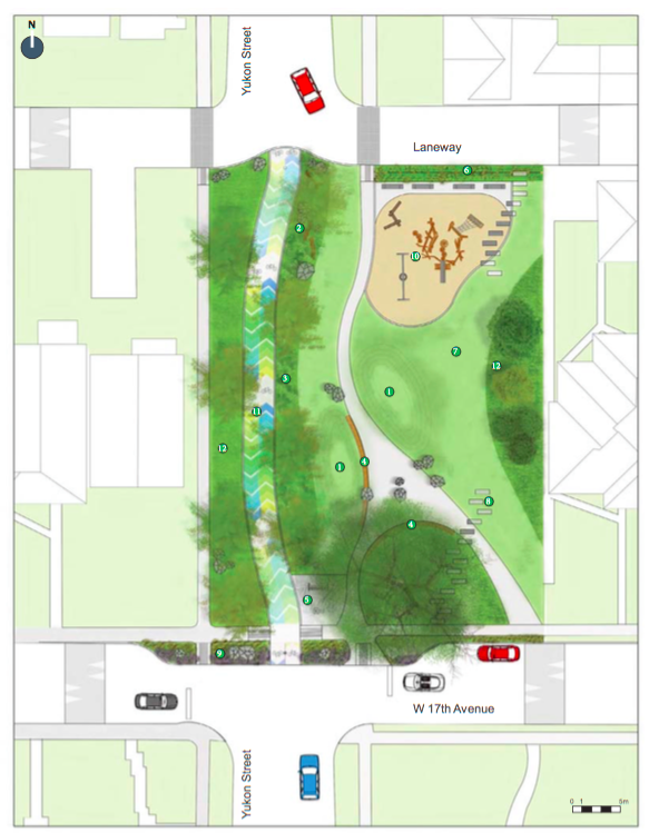
Vancouver does this really well. Here’s an example of a recent project where a park was expanded by 50% by absorbing an adjacent street and including a bike path connection for cyclists. Now look at this drawing and tell me it doesn’t make your mouth water.
We can do this in Toronto.
Take Berczy Park
No, really take it. It’s small enough to hold in your hand probably. Berczy Park is a little, triangular park that needs to be a lot of things to a lot of people: a children’s playground, a dog park, a place to have lunch at work. So the City got creative, god bless them. The park revitalization included a redesign of an adjacent street so that it could seamlessly become a plaza extension of the park when closed to cars. This is a smart, efficient use of very sparse downtown space.

Market Street is another Toronto example, where the City used movable bollards to allow the sidewalk space to expand in the summer to accommodate patios and shrink in the winter to accommodate more car parking. Voila. More space for people. A city that responds to the seasons. A city that is adaptable, modular.
Call it parks that expand and contract.

Okay, but what about money?
Ugh, it always comes back to money, right? While Berczy Park is a great example of creating a more flexible, blended system of public space design, it still used a silo approach when it came to funding.
The City’s park funds (Section 42) went to the redesign of the park and the density bonusing funds (Section 37) went to the street portion. This works if you have access to both funding tools, but since Section 37 funds is generated through denser development, not every ward in the city gets to use it.
Why not allow the use of park funds to do street improvement projects when they are directly related to the continuation or expansion of an adjacent park space? If I’m getting a bigger, better more usable public space then I don’t care where the invisible line is between park and street.
Turns out most people don’t
I went to a public consultation for two small parkettes last winter. A laneway and a small street cut up these two small parkettes, like so:

Guess what everyone at the meeting wanted to talk about? Yup. How to create better connections across these streets and make it safer for children. Guess what the City couldn’t use the money on that they had for the park project? Yup. The streets. All the money had to be spent on the parks when in fact one of the biggest design challenges was how to make the streets that cut through them work better with the parks.
So if we’re going to get flexible with how we design, we need to get flexible with how we fund.
We also need to pay more attention to the edges
When we think about parks we often look inward. Where’s the playground going to go? What about the splashpad? How about those benches? But we need to spend more time thinking about a park’s edges, especially in the smaller parks that are surrounded by downtown streets. How do people enter the park? What’s the experience at the edge? Is there a fence? Can the park be better blended with the sidewalk to produce a better experience?
The redesign of Grange Park is a good example of the importance and power of paying attention to park edges. The Beverley Street side currently has a black iron fence with two entrances on the north and south sides, making this portion of the park much less inviting.

The new design opens the park up on this side, keeping barriers low and using gardens to corral people to certain entry points. It will, I have no doubt, create an entirely new feel for Grange Park along a Beverley Street that will no longer be the “back” of the park, but a whole other front. Just look at all these somewhat translucent people enjoying it.

New York is a great city to turn to for ideas about park edge thinking. They currently have a program called Parks Without Borders that specifically looks at the issue of entrances, exits, and park edges and how they interact with the city and public spaces around them. We could learn a lot from their approach.

So in sum: it’s not always about looking for new and more spaces. Often, in a city like Toronto it’s about taking stock of the spaces we have and thinking about how we can use them better. Can we use a space twice, by designing it flexibly? Is that park better serving its community by removing a fence? Can we design across spaces? Can we spend our money that way?
I not only think we can, I think we have to if we want a public space system that serves the kind of growth we’re expecting in downtown (double the population by 2025). We need to be flexible.
Adapt or die, right?
Next week, the final instalment in this little TOCore trilogy: thoughts on programming and deeper community engagement in our parks.
Photo of Market Street by Marcus Mitanis, title image from City of Vancouver
This post is written by Jake Tobin Garrett. Jake is a writer and wanderer living in Toronto who works as manager of policy and research for Park People